


By continuing to browser our site and use the services you agree to our use of cookies, Privacy Policy and Terms of Use. You can change your cookie settings through your browser.
I agree


From October 28th to the 30th—with many of the island province’s rivers exceeding their danger levels and approaching or even topping their levees—the collision between the remnants of Tropical Storm Trami and a cold front resulted in several consecutive days of heavy rainfall in China’s southern province of Hainan.
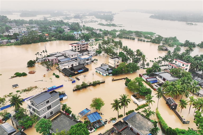
Photo taken on October 30 shows the extreme flooding at Liuke Village, Bo'ao Town, Qionghai. (Photo: Zhang Liyun/Xinhua)
With 183 villages heavily flooded, the seven towns along the Qionghai section of the Wanquan River—the third longest river in Hainan—have been hardest hit. By noon on October 30, more than 47,000 people across the province had already been evacuated to safety, and localities across Hainan were actively engaged in flood control, disaster relief, and secondary disaster prevention work.

A worker from the Nanhai Rescue Bureau of China's Ministry of Transport passes a toddler to a local government staffer at Shibi Town, Qionghai on October 30. (Photo: Yuan Chen/Hainan Daily)
Why is Hainan still being hammered when Tropical Storm Trami has already passed?
According to the Hainan Meteorological Service, this series of high precipitation autumn thunderstorms has impacted a broad area. In the 53 hours from 08:00 on October 28 to 15:00 on the 30th, a total of 38 towns and villages (in Chengmai, Ding'an, Lingshui, Tunchang, Qionghai, Qiongzhong, and Wanning) have reported rainfall in excess of 500 mm; and, of these, four towns have reported accumulated precipitation greater than 900 mm. The single highest amount, at 1062.8 mm, is being reported by Qionghai's Huishan Town.
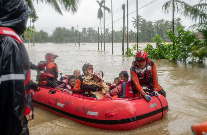
Rescue workers evacuating people by boat at Shibi Town, Qionghai on October 30. (Photo: Yuan Chen/Hainan Daily)
In the 24 hours from 20:00 on October 27 to 20:00 on October 28, the Sanya National Meteorological Observation Station reported that they had exceeded the expected local maximum daily precipitation value for the month of October. In the 24 hours from 20:00 on October 28 to 20:00 on October 29, the Ding’an and Danzhou national meteorological observation stations reported that they had exceeded the expected local maximum daily precipitation value for the month of October.
According to Chief Meteorologist Chen Hong (Hainan Meteorological Observatory), this episode of heavy rain is a typical autumn rainstorm caused by the combined influence of the remains of Tropical Storm Trami and a cold front. September to November is the annual flood season in Hainan. From September onwards, subtropical high pressures begin to weaken, as the mid-latitude westerly trough arrives, and cold fronts start moving southward to southern China. As this coincides with the slow retreat of the South China Sea summer monsoon, tropical depressions are quite common. Therefore, cold and warm air frequently meet here and form low-level easterly jet streams that dump huge amounts of precipitation on the island.
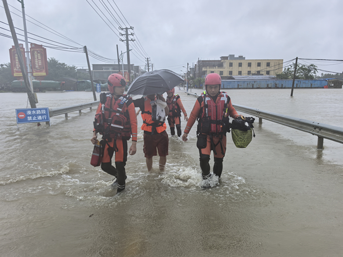
Rescue workers evacuating people in Wanning on October 30. (Photo: Zhuo Xinxin)
From the perspective of spatial distribution and terrain, Chief Meteorologist Wu Shengan (Hainan Provincial Climate Center) explained that Hainan's geography plays a huge role in the autumn flood season, and heavy rain is more likely on the east side of the island and less likely on the west.
Caused by a cloud system with several convective cells passing over the same location in a short timespan, a long strip of rainstorms, like train carriages, were formed during this episode of heavy rainfall, which is called the “train effect” in meteorology. Driven by the residual low pressure center of Tropical Storm Trami in the central and western part of the South China Sea, Trami’s outer shell converged with the moist, cold air from the central and northern parts of the South China Sea. As a result, the central and eastern parts of Hainan Island have been repeatedly hit by extreme rainstorms. At this time, maximum precipitation levels have already exceeded Super Typhoon Yagi that slammed into the island in September.
Secondary disaster and infectious disease prevention is key
On the afternoon of October 30, the Hainan Meteorological Service announced that this round of storms is about to end. However, secondary disasters are still a possibility and—in order to prevent flooding, mountain torrents, and geological disasters—relevant departments must do a good job in the safety management of small- and medium-sized reservoirs.

Photo taken on October 31 shows the floods receding at Jiaji Town, Qionghai. (Photo: Li Tianping/Hainan Daily)
At 18:30 on October 30, the capital city of Haikou has upgraded the flood prevention emergency response in all towns, subdistricts, and neighborhoods along the Nandu River—the largest river in Hainan—from Level IV to Level Ⅲ.
After flooding, numerous factors (such as the damage to the drinking water supply system, destruction of residential facilities, the increased contact between people and potential disease vectors, and a population-wide reduced immune resistance) make outbreaks of infectious diseases (especially of the waterborne and respiratory variety) extremely likely.
The Hainan Provincial Center for Disease Control and Prevention would like to remind everyone to pay strict attention to personal hygiene; to only drink boiled or bottled water; and to maintain air flow.
FTP Expert Talks | Xiaodong Lee, Vice President of the Internet Society of China and Founder of the Fuxi Institution: Hainan is the "Nebula" of New Digital Youth
09:47, 12-September-2025Hainan Issues Offshore RMB Bonds in HK for 4th Consecutive Year
09:46, 12-September-20252025 Hainan FTP International Students Content Creation Project
02:28, 12-September-2025What Makes "Hainan Travel" So Appealing?
09:38, 11-September-2025100 Days to Go: What's Next for Hainan-Hong Kong Cooperation?
09:38, 11-September-2025Expert Talks Ep. 4: The Future of the FTP's Digital Economy
09:35, 11-September-2025
By continuing to browser our site and use the services you agree to our use of cookies, Privacy Policy and Terms of Use. You can change your cookie settings through your browser.
Copyright © 2021 hiHainan.All rights reserved.琼ICP备09005000号-13
 thisishainan@163.com
Partner: Hainan College of Foreign Studies